com2AB: Alpha Beta Model
com2AB calculates the runout of an avalanche according to the statistical \(\alpha-\beta\) model.
An avalanche is defined by its DEM (digital elevation model), a path and a split point.
The runout is calculated according to the \(\alpha-\beta\) model calibrated for avalanches in the Austrian Alps.
It is also possible to adapt the model parameters for other regions.
Input
Please be aware that all input data have to be provided in the same projection.
digital elevation model as raster file with either ESRI grid format or GeoTIFF format. The format of the DEM determines the format of the output files.
set of avalanche paths as (multi-) line shapefile. I.e there can be multiple paths in the shapefile
recommended attribute name
Split points as (multi-) point shapefile. I.e. there can be multiple split points in the shapefile. For each profile/path the closest split point is considered. A split point is the point below which com2AB searches for the beta point. This allows for a better control of the final location of the beta point, since sometimes small flatter sections of the profile can lead to an unwanted beta point. In an operational setting, the split points are set slightly above the expected beta point. It does not need to be precise and it does not have to be on the profile itself (it will get snapped onto the profile).
Outputs
profile plot with alpha, beta and runout points
txt file with angle and coordinates of the different points
To run
go to
AvaFrame/avaframecopy
com2AB/com2ABCfg.initocom2AB/local_com2ABCfg.iniand edit (if not, default values are used)make sure all the required inputs are available in the avalanche directory
enter the path to the desired dataset in
local_avaframeCfg.inirun:
pixi run python runCom2AB.py
Theory
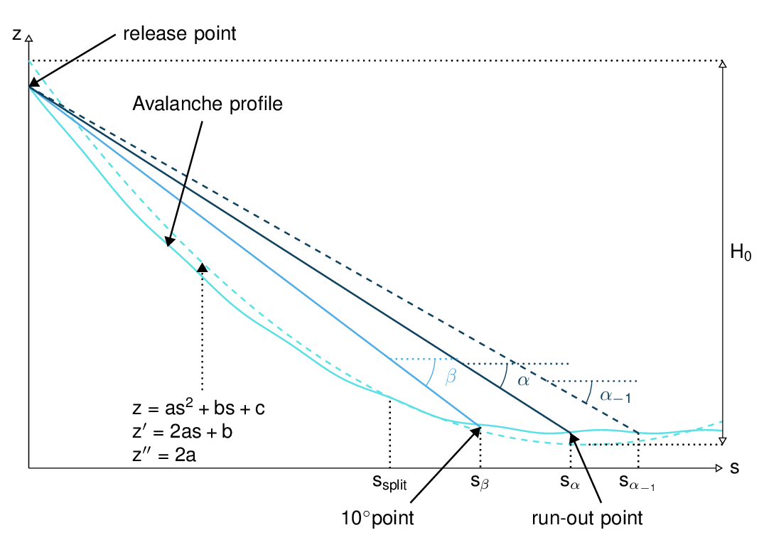
Fig. 1 Topographical variables for the calculation of \(\alpha\)
The snow avalanche runout distance is calculated using a statistical model based on data collected for real avalanches ([BDL83, LB80, Wag16]). An equation of the following type is fitted to the data:
where \(H_0\) is the elevation loss of the quadratic fit of the avalanche profile. \(z''\) is the curvature of this same quadratic fit. \(\beta\) is the angle of the line between the \(10^\circ\) point (first point where the avalanche profiles slope is under \(10^\circ\)) and the starting point. The coefficients \((k_1, k_2, k_3, k_4)\) and the standard deviation \(SD\) are calculated during the fitting process. Index \(j=\{-1,-2,0,1\}\) and \(\alpha_j= \alpha + j SD\). These coefficients obviously depend on the initial set of chosen data. \(\alpha_0= \alpha\) is the angle between the stopping and the starting point of the avalanche. \(\alpha_j= \alpha + j SD\) takes into account the variability of the process. The values of the SD used are based on normal distribution. It is important to note that a bigger runout angle leads to a shorter runout distance. This means that \(\alpha_{-1}= \alpha - SD\) leads to a longer runout. In other words, the probability of the runout being shorter than \(s_{\alpha_{-1}}\) corresponding to \(\alpha_{-1}\) is approximately 83%.
In this module, the coefficients \((k_1, k_2, k_3, k_4)\) and the standard deviation \(SD\) are already known, they are simply used in the \(\alpha\) equation to calculate the runout on a new profile.
Procedure
Preprocessing :
The avalanche path (x,y) is first resampled. Default value for resampling is distance=10m (maximal horizontal distance between two points). Note that it does not make much sense to decrease this value to be smaller than the raster grid resolution. We then introduce the curvilinear coordinate s which represents the projected horizontal distance along the path.
The avalanche path is projected on the DEM to generate the profile using a bi-linear interpolation on the DEM to the point of interest.
The split point (which is not necessarily given on the avalanche path) is projected on the avalanche path.
From this we obtain the (x,y,z) and (s,z) coordinates of the avalanche profile.
AlphaBeta Model:
Find the \(10^\circ\) point from (s,z).
Calculate \(\beta\).
Calculate the \(\alpha_j\) angles using the adequate standard, small avalanche or custom parameter set.
Postprocessing:
Plot and save results.
Configuration parameters
- distance
resampling distance. The given avalanche path is resampled with a step <= 10m (default).
- dsMin
float. Threshold distance [m]. When looking for the beta point make sure at least dsMin meters after the beta point also have an angle bellow 10° (dsMin=30m as default).
- k1
float. Parameter for alpha beta equation
- k2
float. Parameter for alpha beta equation
- k3
float. Parameter for alpha beta equation
- k4
float. Parameter for alpha beta equation
- SD
float. Parameter for alpha beta equation
- smallAva
boolean (False as default) if True apply \((k_1, k_2, k_3, k_4, SD)\) set of small avalanches or False, standard avalanches
- k1_small
float. Use this value if
smallAva=True- k2_small
float. Use this value if
smallAva=True- k3_small
float. Use this value if
smallAva=True- k4_small
float. Use this value if
smallAva=True- SD_small
float. Use this value if
smallAva=True- PlotPath
Plot Avalanche path on raster; default False
- PlotProfile
Plot profile; default False
- SaveProfile
Save profile to file; default True
- WriteRes
Write result to file: default True